As you may have noticed, I can get a little obsessed as new seasons bring new adventures and things to see.
This Spring has been amazing (and still is really!) for California in the wildflower department and I have been determined to catch as much of it as I was able! I spent two action-packed days in Southern California visiting various awesome places - catch up by following the links below!
2) The hot yet cool Mud Volcanoes and still more adorable Owls and Birds.
3) The wacky and yet inspiring artistry of Salvation Mountain and Slab City.
4) Death and Beauty at the Bombay Beach Ruins.
6) See the gorgeous flowers, lizards, and beetle (yes, singular) that I found as I #TrackedTheBloom.
7) I reluctantly take my leave of the Mojave Desert, but not without visiting a couple more amazing places for wildflowers and history!
Okay, now that we've got that out of the way, I have a confession to make. I heard for the Superbloom at Carrizo Plains for a full two weeks during which I bitched and moaned to myself that I had missed it by not getting to Anza Borrega as I had originally intended.
And then, I realized something. Probably from one of the many articles I was torturing myself with, I realized that the Carrizo Plains are NOWHERE NEAR Anza Borrega! In fact, they are in Central California, pretty much directly West from Pismo Beach on the Coast.
Still, that's a pretty long jaunt for a daytrip, but I felt I had to make it! So I did. And, although it was a long, long trip (and had some drama), I don't regret it.
I left early, around 1:00 a.m. after sleeping for only three hours. Kind of stupid, I know.
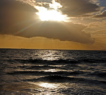
I was about 1.5 hours away when the sun began to rise. Luckily, I was no longer on I-5, so I was able to pull over for a photo op.

The blackbirds were singing and the air was crisp but not too cold. I have never been through this part of California (at least in my memory) so this truly was an adventure!
My directions took me through some pretty sketchy roads...almost dirt and with cattle on either side on periodical open range. It's Spring so that meant adorable babies!

As I came over the hills, the sun was fully risen, but mostly hidden behind intermittent clouds and fog. But there was light enough to see that the fields were truly FILLED with wildflowers of all colors and types. It was freaking gorgeous!


Even the electrical towers crossing the valley were beautiful!

There were lots of ravens flying around and calling for their mates.

I love ravens and I love how his body follows the shape of the fog bank in the distance!

As I drove down Soda Lake Road towards the visitor center, I was amazed at the bright yellow fields that surrounded it!

The visitor center was closed (too early) but I was able to get a map of the park there anyway. As I came back out onto the dirt road back to Soda Lake Road, something prompted me to turn left instead of right.
I knew that the road to Painted Rock - a very cool horseshoe-shaped rock formation that has a pictograph from Native Americans many years ago - was closed except for once per week tours put on by Bureau of Land Management. But I decided to just go that way anyway to see what I could see.
Nothing, pretty much. The road was gated shut, but I decided to get out and look around at the flowers and landscapes. SOOOO glad that I did! I saw a Pronghorn Antelope!

Being very excited, I got right up to the gate to have a better look around. And I saw a herd of about 5-8 antelope just getting onto the road and walking towards me! These pictures aren't very clear because they were quite a bit away (and my lens is soft when full out), but they're good enough to document my encounter with these beautiful animals!


I think this is the moment when they realized I was not part of the landscape.


And they decided they were a little less conspicuous in the tall grass.

After reviewing the map and taking a peek on my gas gauge (the day's drama came from the fact that I had almost zero gas upon reaching Carrizo Plains), I decided that I would have enough for one jaunt up Caliente Ridge Road.
Caliente Mountain makes up the western side of the valley. The hills were painted green and gold with a little bit of blue/purple mixed in here and there.
You can see part of the ridgeline making up the background in the next photo.

I headed through the golden fields on the valley floor and up the dirt Caliente Ridge Road. I knew I wouldn't have time for any hiking, and hoped I had gas for a little four-wheeling!
I passed these very cool rocks near the bottom (this comes into play later, so remember this photo!).

And a cool-looking corral. There are several working ranches in the National Monument area, some of which date back to the 19th century. The Carrizo Plain monument is owned by a mix of the government, the Land Conservancy, and private owners who all work towards understanding this wild land and conservation of it and the many species that inhabit it.


As I drove up the mountain, I began to see the fields of flowers that paint the hillsides.

It was so amazing!

The summit of Caliente Mountain is about 5100' and I think I went maybe to 3500' or so. But this picture is of those massive rocks that I showed you a few pictures back. Tiny, aren't they?

And still, I kept going up.

Until it seemed like the valley floor was another world in another time.

But I wasn't alone...there were people at almost every turn of the road. Campers, people setting off on hikes, people with mountain bikes. It was cool and I definitely want to go back and camp.


The flowers presented such a stunning display of radiant beauty. Truly amazing. And of course I took so many photos. So I'm going to have to do as I did with my #TrackTheBloom posts from Mojave. There will be a shorter post after this one with the best photos and detailed closeup photos of the flowers and birds I saw.

I headed back down the hill (coasting most of the way, thankfully conserving gas) until I was near the bottom. I saw groups of these beautiful lupine bushes, which looked like an impressionistic painting. Monet surely would have approved.

Down on the flat ground once more, there were many picturesque sights to be had.

I love that hill in the background; green on one side and yellow on the other!

I decided to head for Highway 58 towards Bakersfield since I new the so-called "towns" were closer than the last gas station I had passed. What I didn't know was that, although those towns were surrounded by oil fields, none of them had gas stations!
But here's my faithful steed on the dirt road that transverses the Plains before connecting with 58 and heading back through more painted hills.


Soda Lake was full of water (no surprise with all the rain!) but normally it's an alkali wash like the one in the photo below.


Once I got to Highway 58, I saw the hordes of tourist that I had seen articles about, trampling the flowers for their selfies. I really try to stay on path and if there isn't one, I stay put or find one or at least a dirt area. Thank goodness for long lenses as that's how I work most of my shots.

These guys were staying on the path that led over the top of this beautiful yellow hill.

I'll be honest...I was disappointed that I didn't see more purple hillsides. The articles I saw all had photos of hills painted gold on one side and purple on the other. Like this one from the LA Times:

I did see a lot of purple and blue flowers including entire fields full, but they didn't show up like that photo. This one is the closest I got.

I think the purple hills were farther South or I waited too long. I told my daughter I was going to photoshop one of my pictures, so here ya go!

Haha! So Pretty! But, here's what it really looked like. And can someone lend me a couple million so I can buy this ranch? Pretty please?

And my last picture for the day. This is Highway 58 just before you drive out of the beautiful hills and into the decidedly less photogenic oil country hills. This one had a lot of purple to the naked eye, but you wouldn't know that by looking at the photo!

And off I went in search of gas. God was looking out for me because there is no cell service in those hills and I was below empty for a loooonnnnnnggggg time. I didn't find a gas station until I reached I-5! It was pretty scary but I had faith.
xoxo