About Me

My photo
Proud single mom of one beautiful daughter who shares my love of sports and music. She doesn't share my love of the outdoors which I find weird. I love photography and wish I had a better camera!! Maybe someday...
Showing posts with label Mendocino Coast. Show all posts

Wednesday, January 2, 2019

Super Blood Blue Moon January 30, 2018 - Mendocino Coast

So last January, we had a lunar event that I was really excited about.  The Super Blood Blue Moon.  So quick (and basic) lesson:

Super = The moon is in an orbit that brings it close to perigee.  That's the closest point to Earth of the moon's orbit.  To be considered a Super Moon, the moon must be full and be within 90 percent of it's closest approach to Earth.  This makes the moon look bigger than usual - especially when it's close to the horizon. 

Blood = Eclipse!  When the moon is in the path of the sun's shadow (created by earth coming in between the sun and the moon).  I think to be a blood moon, the eclipse has to be a total eclipse.

Blue = The second full moon in the same month.  Unfortunately, nothing to do with actual color. 

Moon = An astrological body that orbits Earth.  

It's not something that happens every month or even every year.  In fact the next Super Blood Blue Moon won't be until January 31, 2037.  And the last one was in 1844!  So I was trying to figure out the perfect place to get some amazing photos and I narrowed it down to two options due to the time/location of the moon at the eclipse:  San Francisco or the Point Arena Lighthouse.  I wasn't sure if the sky in San Francisco was going to be clear of fog and also waiting to long to narrow my choices.  And I was also worried that in the Bay Area, traffic can prohibit you from moving locations quickly if the one you're at isn't working.  

So I chose Point Arena, as I thought that it could be a cool thing to situate my shots with the tall lighthouse in them.  BUT!  I neglected to check to make sure it would be accessible.  And it wasn't.  lol  They were having an event and therefore had blocked off the parking area and road to the lighthouse.  

But more on that later.  I STILL got some pretty awesome pics as I'm good at going with the flow on my road trips.  So on to the pics!!

First I stopped at this cute little village called Fairytale Town.  


The moon wasn't eclipsed yet as it rose above the forested hill. 


Haha!  Just kidding!  Actually, there was a fallen tree stump in my apartment complex that had these cute mushrooms growing.  I had recently bought a lunar lamp and thought I would try to create a cute fantasy shot.  It was fun but people were looking at me weird even though it was after midnight.  lol  

To start my trip, I took a couple shots of the moon which had recently risen over my town.  This first one is how Camera Raw edited the shot in auto.  I thought the green ring looked pretty cool, so I just took it as is and didn't make any adjustments.  :-)


But here is the second shot with my basic edit.  All the closeup shots were taken with a 300 lens and then cropped a bit.  These were taken approximately 1:30 a.m.


I drove about 2 hours until I hit the coast before I stopped again.  At this point, the partial eclipse was just beginning.  This is a color photo but no red could be detected at this time.  Time approximately 3:50 a.m.


I reached Point Arena at about 5:04 a.m., but couldn't find my way to the lighthouse!  Usually my memory of roads and directions is very good, but the dark really through me off.  I went down this road thinking it looked promising. And it WAS!  For seeing FOXES!  Which were too fucking cute!  I saw about 5 of them believe it or not. But they were pretty quick and I was driving so no pics. 

And then I came around a corner and saw this view.  So I pulled over and snapped a couple pics, trying to get the tree branches and stars in it.  It's the almost eclipsed Super Blue Moon!  Woot Woot!

My exposure time was a little too long so the stars are little trails but not really star-trail-ly enough to look cool.  lol  But the moon looks good!

So then I finally found the lighthouse - and that it was closed.  So I found a little spot on the entrance road with this cool tree and snapped a couple shots. I actually illuminated the tree with my car headlights.  Smart, huh?


One of the cool things about a total eclipse is it's the only time to get a shot of the full moon along with a lot of stars.


Again with the mini-trails!
The next photo was taken just after mid-eclipse at approximately 5:31 a.m.


After this, I headed over to Bowling Ball Beach which is a really awesome sight at low tide.  However, low tide was at about 2:30 a.m. and I actually did stop and start the hike there, but chickened out.  It was freaking dark!!!  And scary!  So no.  That will be another trip when low tide is not in the middle of the night. 

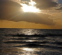
But it was a great setting to watch the Super Blood Blue Moon set into the Pacific Ocean.  And, it was a bit lighter.  So I braved it.  It's a nice little walk and I reached the cliff above the ocean in about 15 minutes. 

This photo was taken at 6:51, about 1/2 hour before the partial eclipse phase was supposed to end. 


7:02 a.m.

7:11 a.m. black and white of Bowling Ball Beach and the last bit of the eclipse.


7:12 a.m. Technically, the eclipse was supposed to end at 7:11, so either it didn't or my times are a bit off.  Could be both honestly. 


Some of the views around me as the sun started to rise in the East. 


The moon was now tinted by the sunrise in the East.  I actually had to reduce some of the yellow/orange glow it was reflecting!  This was at approximately 7:16 a.m.


This next shot is my tripod on the grassy steps of the trail on the cliff.  I took the above shot handheld (I think - this is really why I need to do my edits and post much sooner so I can remember this stuff! and then took the shot of the tripod to show my vantage point. 


Now the eclipse is over and the Supermoon truly looks huge as it hovers over the ocean!  Once thing I didn't realize was how distorted it became once it got close to setting.  Interesting.  


And then it was gone.  Disappearing into the purple fogbank.  


But my day wasn't over yet!  I hiked back to the car and then headed to Fort Bragg to look around a bit.  We'll get there in my next post.  

Oh, and there is another Super Blood Moon coming up on January 20, 2019!  This one is a Super Blood Wolf Moon.  The Wolf part comes from Native American lore where wolves could be heard howling at the full moon in late winter.  This will be the last total lunar eclipse visible in North America until 2027, so be sure to plan your evening!  This one also happens at around 9:00 p.m. I believe so you won't even have to stay up all night!  But be sure to check your local listing...errr....Google it. 😜

xoxo

Nikon D3300

Saturday, January 31, 2015

Lighthouses and Redwoods - Sounds like a Band- 1/17/15

Continuing my roadie from my previous post, as I may have mentioned, I had 6 goals on this trip.  Sadly, only 4 were realized.  

What was also realized is that, despite my predilection for sudden road trips, I'm also a planner.  I guess I'm a fan of spontaneously planning.  Which I did and didn't do for this weekend.

That's okay though because I have a future "redo" to look forward to.  I'm really hoping to make this a fairly regular thing sometime in the not so distant future.  And to be quite honest, I had a really fun and relaxing time so I consider this trip, although aborted, a win!

So my "goals":

1)  To see a few beaches and wander them looking for shells and agates.  -- Check!
2)  To go to Point Arena and climb the tallest Lighthouse on the West Coast.  -- Check!
3)  To see the mouth of the Russian River and possibly do some exploring. -- Check!  Well, no exploring.
4)  To explore the beautiful California Redwoods, preferably in Redwood National Park & the Humboldt Redwoods. --  Check!  Well, kinda.
5)  To make it to Crescent City California and search for agates on Pebble Beach.  -- Noooooo.  
6)  Camp in a random campground near Eureka so I could be central to the Redwoods.  -- Yeah, no.  Didn't happen.

So first, the lighthouse.

I really love the lighthouses of California.  I know some people say they don't compare to the East Coast and I say they are equally wonderful, just different.  I've now explored the lighthouses at Pigeon PointPoint MontaraPoint Reyes, and now Point Arena.

Driving Highway 1 towards the lighthouse in the somewhat misty weather was fun and beautiful.  Except for the lack of bathrooms.  Traveler's beware!  There are no fast food places...no stores...few gas stations.  It is hell on an old woman's bladder.   Sorry.

Anyhoo, back to the gorgeous scenery:


It's easy to see why a lighthouse was needed with all these rocky cliffs.  Fun fact!  The lighthouse is the closest piece of mainland to the Hawaiian Islands!


So gorgeous. The black and brown cliffs, the red roof and white walls of the signal building, and the majestic lighthouse overlooking all.

There are so many places to hike around here.  I really have to go back.  I stopped and walked around the cliffs above the tidal pools when I saw a ton of harbor seals hanging out.  So freaking cute!!  They were watching me right back which was kind of an amazing feeling.


Well, some of them were.  Some were just too chill. 

I had another admirer as I walked around too!  


I have never seen a raven before.  I have seen crows...many, many crows.  And some crows so big that I thought it might be a raven.  But!  When you see a raven you know it's a raven.  Astonishing and cool.  

I kind of love this picture with the way the fence looks.  I would not want to be on the wrong side of that beak!  

I also saw a birdie that was the polar opposite of the stately raven...so little and puffy!  Warding off the cold from his fragile, tiny bones was a White-Crowned Sparrow.  That article says they are large sparrows, but this one and his friends that were flitting around seemed quite small. 

After using the nicest bathroom I had seen on my trip, I made my way into the lighthouse museum/gift shop to sign up for the "tour".  

The First-order Fresnel Lens was amazing.  So beautiful.

We learned that the lighthouse is quite close to the San Andreas Fault line and suffered quite a bit of damage in the 1906 earthquake.   In fact, the original tower sustained enough damage that it was deemed more cost effective to rebuild it rather than fix it. 

Exhibit A

After learning the history of the lens and lighthouse, it was time to make the climb up the stairs.  Between 90 and 144 steps depending on the source.  It seemed like more.


Going up!

The views at the top were simply breathtaking.  This is aptly called "The Sinkhole".


This is the view of my car from the top.  And the nice bathroom.  haha

On my way out, I took a picture of the plaques beside the lighthouse.  Just thought they looked kind of cool.  

And then I ran into my friend, Lenore.  Following me just like the grim portent in Poe's poem.  But I loved it. 
I mean, yeeessssss!  So awesome.  

So here is where things kind of went sideways.  I was talking to one of the nice gentlemen who worked at the lighthouse and I asked him if I was close to any Redwood groves.  He told me there was a beautiful one on Highway 128 and that I should definitely make the drive because it was 10 miles of beauty.

I thanked him for the information, but wasn't sure if it would work in my plan of heading up to Eureka via the coast. 

So I head out and I make it to the mouth of the Russian River, which was gorgeous, but not exactly as I remembered through the eyes of my 10-year old self which was the last time I remember being there.

Just after passing through, I came to a fork in the road where I had to turn either left or right.  Left, my sense of direction knew, was towards the coast.  Right, the sign informed me, was Highway 128 TO EUREKA.  This confused me.  

But I figured, "Jeah!  I can see the Redwood grove and still be heading to Eureka!"  My brain and sense of direction were saying, "Don't do it!"  But I turned right...and pulled over to the side of the road after about 100 feet.  I started to turn around.  I was really at war with myself.  But the SIGN!  It said Eureka!  

I finally pulled out my phone to check GPS and NO SERVICE!!  The first time Verizon has failed me ever.  lol  So I decided to continue on Highway 128 because EUREKA!

At first it was a good decision.  I was soon ensconced on a nice, twisty road surrounded by an old, emerald and red grove of tall trees. 

I saw this fallen, hollow trunk and couldn't resist pulling over and walking around a bit.  It turned out to be an actual grove with markers, although you couldn't see them from the road.  I think that kind of defeats the purpose.

The backside:
So many shades of green and grey.  With beautiful browns thrown in.  The trees...the ferns...  I just love the forest.

 Each tree is a work of art.
 And mixed in with the ferns were clovers!  Everywhere!  

 So much luck in this picture!  A horseshoe covered in clovers!

And the ferns I tell ya!  I love ferns.  #Olicity


After I left the Redwood grove, I became increasingly uneasy that this damn road was NOT going to take me to Eureka.  It was definitely going the wrong direction.  

It was fun because it was super wind-y (not to be confused with windy) and pretty.  I love pretending to be a race-car driver and pushing myself on roads like that.  So I really enjoyed it.  AND I saw the Husch Vineyards!!  My favorite wine is a Husch Late Harvest Gewurztraminer.  OMG so delicious.  I must go back and go wine-tasting now that I know where they are.

So bottom line...this damn road headed back towards the Bay Area and connected with Highway 101 WAY below where I was on the Coast.

Exhibit B
Dammit!!!

So my goal of reaching Eureka by 5:00 pm ish was torpedoed and I didn't get there until 8:00 even though I drove straight up 101!  And you know what?  Campgrounds in that area close at 6:00.  So me=screwed.  I contemplated sleeping in a parking lot somewhere but there were too many sketchy people around.  

I ended up driving all the way back to Sacramento (arriving at 3:30 a.m.!) after driving around Eureka and the surrounding areas for awhile trying to find a campground that was open and/or would let me stay there.

That's where the better planning would have come in.  That and having a map.  lol 

It was a fun time though.  I loved it and felt really rejuvenated by being out in nature and seeing God's beauty.  

Can't wait for next trip!  

xoxo